


NOTE: We rode this route again on June 19, 2010, using a Garmin 310xt to record, then map, the route. Check out that blog post here, or the Garmin Connect map-and-more page here.
A bit of map study and also just paying attention while out on road rides helps Rough Riders to find yet more dirt road adventures to be enjoyed. We've ridden out on the roads of north-eastern San Diego County quite a few times. The terrain and scenery in the Ramona - Santa Ysabel - Mesa Grande area is wonderful. Alas those roads are almost unrideable now, especially on weekends, because of casinos, the wholly disproportionate enthusiasm for the pie town of Julian, and especially the "desert rat" traffic passing through here en route to and from the desert in RVs pulling desert-trashing motorized vehicles. Thus it was our goal to find a way to enjoy some of this area, while avoiding as much motor vehicle traffic as possible.
Below are some photos, the route sheet, and a video from a 43 mile loop we did on November 15, 2008 out in this region. The 13.2 miles of dirt road on this loop is entirely rideable on a road bike with 25mm tyres, or even 23 if you're careful, but we went a little wider.
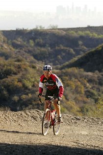
I rode my 1984 Holdsworth Special, a British sport-tourer which was my first ever sponsored bike. Originally, back in 1984, I set it up with all Campy Super Record and tubular wheels. This was my first pro-level racing bike and I rode it during my San Francisco to Los Angeles world record on April 17-18, 1984, when I was 17. A year later I became sponsored by American custom frame builder Ron Stout and so the Holdsworth became my back-up bike. After racing RAAM in 1987 I pretty much quit riding the Holdsworth. I think it's been sitting around for literally 20 years with no parts on it. Recently I put it together as a Rough Stuff bike with most of the parts, and wheels, from my Bridgestone RB-1. Thus it's mostly Suntour parts with Phil Wood hubs and bottom bracket, and 700x by 32mm Vittoria Cross XN Pro tyres and 38/28 low gear. This bike is an absolute dream for Rough Riding! (I'll do a full post just about this bike at a later date.)
Whatever bike you ride, this is simply a really nice ride to do. The dirt road section through Black Canyon is superb, with lovely views, vast quantities of silence, and a nice back-country feel (though while riding a very wide and graded dirt road.) If you pay attention, you'll spot some other dirt roads in the area; we plan to go back and investigate those, too. Now, here are some photos, the route sheet, plus a video:
Click any image to see it much larger!A bit of map study and also just paying attention while out on road rides helps Rough Riders to find yet more dirt road adventures to be enjoyed. We've ridden out on the roads of north-eastern San Diego County quite a few times. The terrain and scenery in the Ramona - Santa Ysabel - Mesa Grande area is wonderful. Alas those roads are almost unrideable now, especially on weekends, because of casinos, the wholly disproportionate enthusiasm for the pie town of Julian, and especially the "desert rat" traffic passing through here en route to and from the desert in RVs pulling desert-trashing motorized vehicles. Thus it was our goal to find a way to enjoy some of this area, while avoiding as much motor vehicle traffic as possible.
Below are some photos, the route sheet, and a video from a 43 mile loop we did on November 15, 2008 out in this region. The 13.2 miles of dirt road on this loop is entirely rideable on a road bike with 25mm tyres, or even 23 if you're careful, but we went a little wider.
I rode my 1984 Holdsworth Special, a British sport-tourer which was my first ever sponsored bike. Originally, back in 1984, I set it up with all Campy Super Record and tubular wheels. This was my first pro-level racing bike and I rode it during my San Francisco to Los Angeles world record on April 17-18, 1984, when I was 17. A year later I became sponsored by American custom frame builder Ron Stout and so the Holdsworth became my back-up bike. After racing RAAM in 1987 I pretty much quit riding the Holdsworth. I think it's been sitting around for literally 20 years with no parts on it. Recently I put it together as a Rough Stuff bike with most of the parts, and wheels, from my Bridgestone RB-1. Thus it's mostly Suntour parts with Phil Wood hubs and bottom bracket, and 700x by 32mm Vittoria Cross XN Pro tyres and 38/28 low gear. This bike is an absolute dream for Rough Riding! (I'll do a full post just about this bike at a later date.)
Whatever bike you ride, this is simply a really nice ride to do. The dirt road section through Black Canyon is superb, with lovely views, vast quantities of silence, and a nice back-country feel (though while riding a very wide and graded dirt road.) If you pay attention, you'll spot some other dirt roads in the area; we plan to go back and investigate those, too. Now, here are some photos, the route sheet, plus a video:


 Here is the route sheet. Bring a San Diego County map for reference. Plan on about four to five hours, total time. If you want to minimize the trafficky roads, you could go out and back on Black Canyon Road, simply turning around at mile 18.5. However, be sure to bring plenty of water and food as you will find no supplies, and essentially no people, on this route if you do that!
NOTE: We rode this route again on June 19, 2010, using a Garmin 310xt to record, then map, the route. Check out that blog post here, or the Garmin Connect map-and-more page here.
0.0 Start on Hwy 78 at Day Street. Proceed east on Hwy 78.
2.5 Left / north Magnolia Rd.
5.3 Pavement ends.
9.9 You'll reach the Black Canyon Road Bridge, built in 1913. Our route goes left here, but not yet; first continue straight, past the bridge, to Sutherland Reservoir.
10.75 At the top of this road, you'll hit a T-Intersection. Go right just a little bit.
10.9 On your left you'll enjoy a nice view of the dam and Sutherland reservoir. Enjoy the view, then turn around here and retrace your steps to Black Canyon Road Bridge.
11.9 Turn right over the bridge.
13.8 Pass a Fire Station adjacent to the Indian Reservation. Water, perhaps?
18.5 End dirt road, and the summit, as you reach the T-Intersection with Mesa Grande Rd. Go right.
25.0 T-Intersection at Hwy 79. Go right towards Santa Ysabel. Careful: Not much shoulder; traffic very likely; side wind very possible. Careful!
26.9 T-Intersection at at Hwy 78. Go right / west and stop at Dudley's for water, bathroom, bakery. Continue west on Hwy 78. Careful: Not much shoulder; traffic very likely. Careful!
32.0 On a fast, somewhat downhill stretch, veer Left onto Old Julian Hwy. DO NOT STAY ON Hwy 78 unless you like lots of traffic on a narrow, winding road with no shoulder! Almost immediately after you veer left, look for camels and llamas on your right!
39.0 Stay Right on Old Julian Hwy (Stop Sign; T-Int).
Entering Ramona, take D Street left / west as a parallel alternate to riding on the main drag (Hwy 78).
42.8 Turn Right on Day Street, then cross Hwy 78 to the start/finish.
Congrats! Send us your comments, ride data, photos, etc!
Below: Here's a video of the whole ride, but don't waste your time on this little, itty-bitty version! Instead, click here for the full-size Quicktime slideshow with large images which we have hosted on our website. There are 57 images, plus a soundtrack (turn up speakers), so it should be pretty fun and interesting. Let us know what you think by posting a comment below! Thanks for your support and interest!


1 comment:
Wow! What a great ride! The slide show is great.
-JimD
Santa Clara, Ca
Post a Comment