
On Monday, November 9, 2009 I spent five hours riding the main route for the July 23-25, 2010 Rough Riders Rally with my good friend Ed Levinson. Here are some photos from that adventure today.

 Above: That's Mt. Diablo in distance, east across the Bay. I rode there yesterday, as you can see in this self-portrait from the ride up the mountain:
 OK, back to the Rough Riders Rally recon pix:

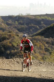
 Above: Ascending Green Gulch Trail, with Mt. Tam in the background.


 Above: Descending Miwok Trail to Rodeo Beach, Ed met a friendly coyote.
 Above: Ed above Rodeo Beach and its WWII era buildings. Bike: 1993 Bridgestone MB-1.
 Above: Yours Truly above Rodeo Beach, en route to Battery Townsley. Bike: 1984 Holdsworth (my 1984 SF-LA record bike) with 32mm Ritchey 'cross tyres and 38/28 not-very-low gear.
 Above two pix: Dropping down to Rodeo Beach from Battery Townsley.
 Parting shot: Ed and Chris, friends since 1987.
The Rough Riders Rally is our new annual mixed-surface (road / trail/ etc) cycling festival based in Marin County which celebrates the "Any Bike, Anywhere" ethos. It promises to be a very fun weekend in an absolutely spectacular cycling paradise. Mark your calendar! (Mountain bikes are welcome, too!)
Click here for a preview slideshow (from the first Rough Riders Rally route recon) and a very rough route sheet of the Saturday route for the 2010 Rough Riders Rally. The route is approximately 45 miles with approximately 5000' of elevation gain and features single track, double track, fire road, gravel road, abandoned paved road, and newly paved road. Some consider this "mountain bike territory," but this route is 99% rideable by an accomplished Rough Rider on a road bike with 32mm cyclocross tyres (or on a cyclocross bike), and perhaps 90-95% rideable on a road bike with 28mm road tyres.
Special thanks to my long-time friend and local guide, Ed Levinson, a Furnace Creek 508 veteran who owned and operated a bike shop in Mill Valley for over ten years. (Our host shop for the Rally will be Mt. Tam Bikes at 357 Miller Avenue, as pictured in the slideshow.
This region offers truly superb cycling, with fantastic views of the San Francisco Bay, Alcatraz, the Marin Headlands, Mt. Tamalpais ("Mt. Tam"), Tiburon, Mill Valley, the Bay Bridge, a bit of the Golden Gate Bridge, and dramatic, rugged Northern California coastline. Honestly, this is cycling paradise, a region unparalleled for its beauty, diversity of scenery and riding surfaces, and its cycling-friendly trail signage and local population!