
One of my most prized bicycles is for sale. It's an incredible piece of history and an amazing performer. Includes a Letter of Authenticity from yours truly, too.

Some of the description:
"This is among the finest builds I've seen on an RB-1, and it's owned by then Bridgestone sponsored racer Chris Kostman. Chris's red 93 RB1 he was racing was stolen, and Grant Petersen gave him this one to replace it (full story in letter of authenticity in images). The build starts with a period correct 7 speed last gen Suntour Superbe Pro groupset including the rare hidden spring brakes & Avocet R1 saddle. It gets a little less period correct from there but stays towards classically styled (ish) top level parts. Highlights include Chris King Classic hubs laced to Campagnolo Montreal 76 rims, Nitto Lugged quill & Dream Bars.
"The RB road bikes were special beasts for their time. They took styling cues from classic Italian racing bikes and made it more functional and practical. The frame/fork fit up to 32mm tires (perhaps 28mm with fenders), and slack-ish angles for a more comfortable ride, and fender eyelets front and rear. Plus, they feature that gorgeous biplane fork crown!
"The frame and components are in lovely condition, and Chris says both have about 1,000 miles total. Always stored indoors and maintained by a pro mechanic. Decals are pristine or very close to it with exception of some wear on the seat stay RB-1 decals. Components are in wonderful mechanical condition, with some light cosmetic wear."
Visit BikeRecyclery.com to check it out - and make it yours!
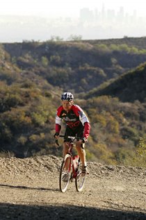
Below: That's me with my mentor, Race Across America founder John Marino, astride my 1993 RB-1 during the 2008 Solvang Century: