


 We love the whole Mt. Laguna region for cycling on- and off-road, for its beauty, its diversity, its flowers, its waterfalls, and so much more. It's truly an outdoor paradise, and it's located just 50 miles east of San Diego, along the I-8 freeway. We've ridden every road out there, and many of the trails, but we never tire of creating new ways of connecting together the various pieces we know, interspersed with some new treats along the way. Such was the ride we did on November 8, 2008, a 59.5 mile loop which started and finished at the relatively new Starbux located at 2963 Alpinie Blvd in Alpine, CA 91901. (Start location and mapping here.)
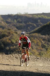
This route included the fabulous Viejas Grade ascent (pictured above), a gravel and dirt road which is a wonderful alternate to riding on I-8 just to the south (the corridor that 99% of all cyclists use out here for some reason to get between Alpine and Descanso). Viejas starts behind the Viejas Casino and climbs up to the top of the mountains immediately west of Descanso. It's a great climb, not that steep, and doable on road bikes with 23mm tyres if you're careful, though 28mm or wider is advisable. This ride then goes through Descanso, Guatay, and Pine Valley, then climbs the little known and truly EPIC Pine Creek Road (again, 99% of cyclists bypass this road and just climb Mt. Laguna on Sunrise Hwy for some unknown reason). Pine Creek is one of the very best climbs anywhere on the planet. At the top you go south on Sunrise Hwy, either directly to the summit - where you'll find a nice little Forest Service visitor's center, bathrooms, store, and rental cabins - or you can have some extra fun and a bit more dirt by cutting through the campgrounds instead (as we did, which you'll see in the slideshow and below), still ending up at the store and bathrooms.
From the summit you actually climb a bit more, then enjoy a very long descent down Sunrise Hwy back to Pine Valley. From Pine Valley there is a short amount of retracing one's steps in reverse to Guatay, but then we head south towards the I-8, instead of back to Viejas Grade. Then it gets extra interesting again where we investigate an alternate to either riding the I-8 shoulder or Viejas Grade to get back to Alpine. I had seen this third option, a clearly abandoned road, from the freeway over the years and finally checked it out on this ride. You can see what happens in the slideshow/video, but it's pretty neat. You do end up back on the freeway shoulder, but only for a downhill mile or so, before exiting back into Alpine. This was a really great ride and we highly recommend it! Post your comments about your own adventures on this route below!
Here is the route sheet. Note that not every turn is measured in. Bring a San Diego County map for reference, though if you have a good sense of direction and have plenty of time, you should be able to figure out this ride with what is below. Plan on about six to seven hours, total time.
0.0 Start at Starbux in Alpine and head east on Alpine Blvd.
Cross over I-8 at Willow Glen, then continue east on the opposite (north) side of the freeway.
Veer left shortly thereafter into the Indian Reservation.
Follow that road until it becomes Viejas Grade and turns to gravel - head uphill into Rough Rider heaven!
7.8 Summit Viejas Grade (still gravel).
8.8 Pavement resumes: Continue straight and downhill to Descanso.
Turn left at the T-intersection at the store and stop sign.
Turn left at the next T-intersection at the 79 / Old Hwy 80 stop sign.
Pass through Guatay, then drop down into Pine Valley.
17.8 Pine Valley Park (water and restroom; use these facilities!)
U-turn back a half-mile, then turn right on Pine Creek Rd (north); get ready to start climbing in a few miles.
After an extremely steep section (see the comments below), you'll cross a cattle guard, then make a hard right straight uphill (not straight onto the dirt there).28.2 Turn right/south on Sunrise Hwy (T-intersection; stop sign).
33.0 Visitor's Center at the summit of Mt. Laguna (water and restroom); there's also a store next door.
Continue south on Sunrise Hwy, dropping down towards the I-8 and Pine Valley.
At the bottom, turn right on Old Hwy 90 to Pine Valley.
Pass through Pine Valley, including Pine Valley Java and Major's Café.
44.2 Arrive back at Pine Valley Park (water and restroom).
Continue west on Old Hwy 80 through Guatay.
Continue onto 79 - not back to the Descanso Store, unless you want or need to.
51.5 About a mile before hitting the I-8, turn right on Willow Glen.
About a mile later, there is a gate across the road and then the pavement starts to disappear: keep going!
54.0 Hike down onto I-8 and continue west on I-8 (this is a bike-legal bike lane shoulder).
Take first offramp, then left over the freeway, then right on Alpine Blvd, continuing west back to Alpine.
59.5 Finish at Alpine Starbux.
Here are some photos (click any of them to see them much bigger):
 Above: On Viejas Grade, looking west; You'll see lots of "Spanish Bayonets" in this region, as featured in the Rough Riders logo!
 Above: Starting to climb Pine Creek Road.
 Above: Further up Pine Creek Road. What a view, in every direction!
 Above: Near the top of the first main summit of Pine Creek Road. The previous photo was taken in the far left of this shot, looking up to where we are now. This road rules!
 Above: Cutting through the campgrounds, and enjoying all the fall colors, as an alternate to part of Sunrise Hwy, on the way to the Mt. Laguna Visitor's Center.
 Above: Ready to rumble! On Willow Glen, heading to where the pavement turns to dirt!
My Bike: 1994 Bridgestone RB-1 with 700x by 32mm Vittoria Cross XN Pro tyres and 38/28 low gear. On me: Major Taylor jersey and Moeben sleeves. (Her bike: 1974 Williams with 650B by 35mm Panaracer Col de la Vie tyres and 34/32 low gear.)
 Above: Willow Glen rough riding - pavement is overrated!


3 comments:
Nice ride and description. That is a great area. We used to call the first section of Pine Creek Rd "The Steepest Paved Road In The World." When you got to the top of Pine Creek Rd did you turn right, continuing on a paved surface? That should be Deer Creek Rd. I think Pine Creek Rd continues as a pretty beat up dirt road past that top of the first climbing section.
Thanks! I missed that detail, which would probably send somebody on the "wrong" route - although you'd still eventually end up on Sunrise Hwy. However, I'm looking at my Thomas Guide and it appears that the straight ahead section (at the point where there's a cattle guard and our route makes a hard right, straight up hill) is Deer Park Rd. "Our" route actually changes name to Laguna Meadow Rd., something I'd never noticed, but which definitely makes sense. I will update the "route sheet" here on the post now. Thanks for bringing this to my attention!
Note to readers: You can see the Blackmountaincycles blogger posing with a classic red Ritchey in our "Fifty Mile Ride Exceeds Expectations" post here on this blog. And if you're ever in Marin County, be sure to check out his bike shopt!
I am so envious! What kind of weather is that, amigo? On Dec 30, I rode 230 K's in the Willamette Valley. No rain but way cold, 34>39 and much colder when the route touched the foot hills of the Oregon Coast Range. Brrr! I got some hot soup at the 100K point, that did the trick.
Today, Dec 31, it's 44>45. I went out for some bagels and thought, OMG, it's 10 degrees warmer today, and I'm freezing my buns off. I must be nuts!
No comment on that one, Chris.
;-)
Post a Comment