


You're Invited: Multi-Surface Semi-Epic Ride in the Santa Monica Mountains on Sunday, May 27
 I'm planning to string together a bunch of trails, fire roads, and paved roads in the Santa Monica Mountains for a nice adventure ride on the Sunday of Memorial Weekend. You are welcome to join in the fun, so please help spread the word. The emphasis will be on quieter, more remote trails and as few paved roads as possible, to avoid holiday weekend traffic. Stay tuned to this webpage for further details.

Route: It's about 50 miles with about 7500 feet of elevation gain, so figure 5-6 hours. There will be some bail-out options for those who want to do less. We'll start on the edge of The Valley and head up high from there, enjoying views such as those featured on this previous semi-epic ride preview and post-ride report from the same region.
Here is the intended Route:
South (uphill) on Topanga to "Top of Topanga".
Right on Summit to Summit Motorway, taking it across the summit of Old Topanga Canyon Road, then straight onto Calabasas Peak Motorway.
This drops down to Stunt Road, then ascend Stunt Road to Schueren. (Bail Out Option 1: turn right on Stunt instead and then right on Mulholland, back to the start)
Take Schueren to Piuma, and descend Piuma.
Turn right, briefly, on Malibu Canyon / Las Virgenes. (Bail Out Option 2: continue on Las Virgenes to a right on Mulholland and back to the start.)
Turn left, UPHILL at Tapia, straight up Mesa Peak Mtwy to the Backbone Trail.
Go west across the ridge on Backbone Trail, crossing the top of Corral Canyon.
Continue west on Backbone Trail, then descend Bulldog Trail.
At the bottom of Bulldog Trail, turn right and traverse east through Malibu Creek State Park. (If this seems too full of hikers, we'll instead go left and exit the Park via Malibou Lake and then Mulholland.)
At Las Virgenes, go right towards the coast to Piuma. (Bail Out Option 3: go left on Las Virgenes and right on Mulholland, back to the start.)
Turn left on Piuma, then left on Cold Canyon Road.
Continue on Cold Canyon / Dry Canyon as much as possible, otherwise Mulholland, back to Topanga Canyon and our start/finish at the Dumetz Starbucks.
Here is a RideWithGPS preview of the route (Thanks to AllRoy71!): Click
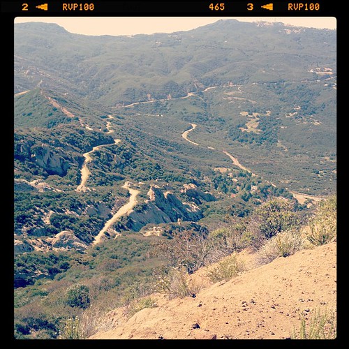
Note: On May 17 I rode a loop that featured the first ten and the final eight miles of this route with 2500 feet of elevation gain. Here is the Strava page. Based on that brief recon, I am going to raise my guesstimated elevation gain to 7,000-8,000 for the day and six hours total time. My low gear was 34x30 and I could just barely hold traction (while necessarily seated) with 650B Grand Bois Hetre tyres on the super steep uphills at 60 psi. I am probably going to run 50 psi on the 27th, at least for the dirt stretches. Here is a shot of Stunt Road in the distance and the downhill part of Calabasas Peak Motorway (fire road) which leads down to Stunt:
Meet-Up (start/finish): 730am, Starbucks on Topanga Canyon at Dumetz: 4900 Topanga Canyon Boulevard, Woodland Hills, CA 91364: Google Map of the location.

Here is the intended Route:
South (uphill) on Topanga to "Top of Topanga".
Right on Summit to Summit Motorway, taking it across the summit of Old Topanga Canyon Road, then straight onto Calabasas Peak Motorway.
This drops down to Stunt Road, then ascend Stunt Road to Schueren. (Bail Out Option 1: turn right on Stunt instead and then right on Mulholland, back to the start)
Take Schueren to Piuma, and descend Piuma.
Turn right, briefly, on Malibu Canyon / Las Virgenes. (Bail Out Option 2: continue on Las Virgenes to a right on Mulholland and back to the start.)
Turn left, UPHILL at Tapia, straight up Mesa Peak Mtwy to the Backbone Trail.
Go west across the ridge on Backbone Trail, crossing the top of Corral Canyon.
Continue west on Backbone Trail, then descend Bulldog Trail.
At the bottom of Bulldog Trail, turn right and traverse east through Malibu Creek State Park. (If this seems too full of hikers, we'll instead go left and exit the Park via Malibou Lake and then Mulholland.)
At Las Virgenes, go right towards the coast to Piuma. (Bail Out Option 3: go left on Las Virgenes and right on Mulholland, back to the start.)
Turn left on Piuma, then left on Cold Canyon Road.
Continue on Cold Canyon / Dry Canyon as much as possible, otherwise Mulholland, back to Topanga Canyon and our start/finish at the Dumetz Starbucks.
Here is a RideWithGPS preview of the route (Thanks to AllRoy71!): Click
Note: On May 17 I rode a loop that featured the first ten and the final eight miles of this route with 2500 feet of elevation gain. Here is the Strava page. Based on that brief recon, I am going to raise my guesstimated elevation gain to 7,000-8,000 for the day and six hours total time. My low gear was 34x30 and I could just barely hold traction (while necessarily seated) with 650B Grand Bois Hetre tyres on the super steep uphills at 60 psi. I am probably going to run 50 psi on the 27th, at least for the dirt stretches. Here is a shot of Stunt Road in the distance and the downhill part of Calabasas Peak Motorway (fire road) which leads down to Stunt:
Meet-Up (start/finish): 730am, Starbucks on Topanga Canyon at Dumetz: 4900 Topanga Canyon Boulevard, Woodland Hills, CA 91364: Google Map of the location.
Departure: 800am sharp.
Bring: Three water bottles and/or hydration pack, plus food, two tubes, patch kit, tools, and more. It will probably be hot out there and water only occasionally available along the way.
Note:
This ride is unhosted, unsupported, and everyone who shows up is on
their own. Neither we, nor anybody else, is responsible for anyone who
rides. If you ride, YOU are responsible for YOU and YOUR bike. This is
not an "event" - it is just a ride on dirt and paved roads for
like-minded people.
Remember: We Rough Riders enjoy getting "out there" by riding roads, dirt roads,
trails, and paths on whatever bike we happen to be on or have handy.
Sometimes the pavement's long gone and we're still on our "road bikes"
or some bike that would be commonly considered inadequate for the job -
and that's just fine by us! Rough Riding is not defined by the type of
bicycle or type of riding surface. Rough Riding is a state of mind, a
riding style with limitless freedom and an all-pervasive sense of
adventure. I will be riding my Rawland rSogn, probably with knobby tyres or possibly with treadless 42mm Grand Bois Hetres.


2 comments:
Following your directions, I came up with this map. I think some spots are a bit off, since I don't know all the trail names.
http://ridewithgps.com/routes/1187100
Ridewithgps seems to add a little elevation too, but I think it will be about 7000 ft climbing.
I hope to make the ride, but I think I will need to use my mountain bike, instead of my CrossCheck, to make some of these grades (up and down)!! Would the bail out be before Tapia?
A full set of pix will go up on Flickr soon, as well as a blog report. Meanwhile, here's the pix I sent out via Instagram during the ride:
http://pictajam.com/chriskostman
Here's the Strava link:
http://app.strava.com/activities/9512966
Here's the Garmin Connect link:
http://connect.garmin.com/activity/182796935
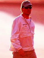
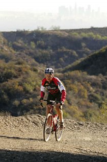
Five illustrious cyclists showed up to join me - including two Rough Riders Rally alumni - and we had an absolute blast! Bikes included:
Rock Lobster
Salsa A La Carte
Specialized Expedition
Stinner Single-Speed (custom builder in Santa Barbara)
Surly Cross-Check
My Rawland rSogn
Post a Comment