

Seeking inspiration and wisdom wherever it may be found, the Rough Riders ride Any Bike, Anywhere.
- Chris Kostman
- Welcome to the internet home of the Rough Riders. Our slogan is "Any Bike, Anywhere" and we believe in riding any distance, in any conditions, over any terrain, at any time of day or night. That sounds really hard-core, perhaps, but mainly we enjoy getting "out there" by riding roads, dirt roads, trails, and paths on whatever bike we happen to be on or have handy. Sometimes the pavement's long gone and we're still on our "road bikes" or some bike that would be commonly considered inadequate for the job - and that's just fine by us! Rough Riding is not defined by the type of bicycle or type of riding surface. Rough Riding is a state of mind, a riding style with limitless freedom and an all-pervasive sense of adventure.

Rough Riders are a subset of AdventureCORPS, Inc.

Setting the first San Francisco to Los Angeles world cycling record in 1984

About a year after inventing "underbiking" on Westridge Trail, Redwood Park, Oakland, CA, 1992

About a year after inventing "underbiking" on Westridge Trail, Redwood Park, Oakland, CA, 1992

At the 24 Hours of Canaan in 1993, with my Bridgestone teammates (L-R) Harry Winand, Gene Oberpriller, and John Stamstad, plus one of our XO-1 bikes

Noble Canyon Trail, Mt. Laguna, San Diego County

With Grant Petersen, Mt. Diablo, Walnut Creek, CA

With Tom Ritchey in Oceanside, CA at RAAM 2006

With AdventureCORPS Fan #1, Bill Walton, during the 2010 Million Dollar Challenge

On Dirt Mulholland above LA, during a Rough Riders Semi-Epic

With Brian Frank, CEO of Hammer Nutrition, during Hammer Camp Tucson

With the godfather of ultracycling, my mentor, John Marino, during the Solvang Century

With Ed Levinson, Miwok Trail, Marin County

With Jan Heine of Bicycle Quarterly at Cirque du Cyclisme in Greensboro, NC

With my beloved Bridgestone RB-1 bicycle
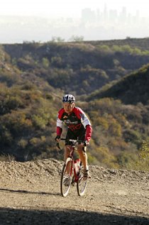
Canyonback Fire Road, Brentwood, CA (LA Times)

Canyonback Fire Road, Brentwood, CA (LA Times)

In Rancho Penasquitos, San Diego, CA with my classic Moots

With Sky Boyer at The 50 Mile Ride, Orange County, CA

With my mascot Gumby in Utah during the 1987 Race Across America

In the beautiful Midwest during the 1987 Race Across America

At the finish line of the 1987 Race Across America. I rode THAT rough rider for just the last nine miles of the 3,127 mile race!