

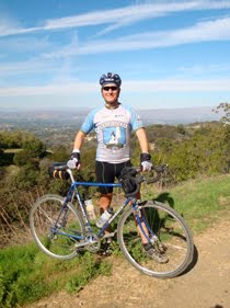
 Above: My Rivendell Roadeo at the picnic area along Railroad Grade at the West Point Inn.
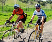
On Saturday, June 26 of my recon visit I rode the route which is suggested for Saturday of the Rough Riders Rally. It is one TOUGH route. It is "only" 36.5 miles, however these are 36 and a half of the most beautiful miles one could ever ride, plus there is a total elevation gain of 5,764 feet. Most century cycling events have less climbing than that!
The route features single track, double track, fire road, gravel road, abandoned paved road, and newly paved road. Some consider this "mountain bike territory," but this route is 99% rideable by an accomplished Rough Rider on a road bike with 32mm cyclocross tyres (or on a cyclocross bike), and perhaps 90-95% rideable on a road bike with 28mm road tyres (some of the long downhill parts might make some people nervous on skinny road tyres).
This time, I rode my Rivendell Roadeo with a low gear of 38 front x 28 rear, shod with Ritchey Speedmax Cross tyres, which have a small amount of tread on them.
Here's a map and a dozen photos from this recon ride, but be sure to check out the Garmin Connect page to interact with the map, elevation profile, and more! (All images below are in order as if riding the route.)
Also, be sure to check out the full slideshow of this route (from my previous recon rides).
Finally, I have a Pdf of the route sheet for this ride online here (use at your own risk).


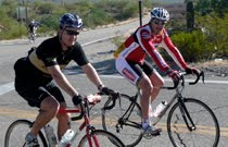
 Above: I stopped because this couple had a rare Otis Guy mountain tandem, then they pointed out the lovely flowers, and then I learned that the male half of this dynamic duo is Owen Mulholland, the legendary cycling journalist and author! What a treat to meet them both! I invited them to attend the RR Rally and I hope they do! (They had slick tyres on their tandem, by the way!)
 Above: Our route crosses the world-famous Dipsea Trail (from Mill Valley to Stinson Beach) and I encountered the Double Dipsea race during my ride!
 Above: We exit the Zen Center's Green Gulch Farm via this gate. Next up is some seriously steep single track with a few gnarly 180 degree switchbacks.
 Above: During a rare nearly flat part of the Middle Green Gulch Trail. On the steep parts, you do not want to dab or you will have a difficult time getting restarted!
 Above: Self-portrait with Mt. Tam behind, at the intersection of the top of Middle Green Gulch Trail and Coyote Ridge Trail.) The camera's POV is north by northwest.
 Above: Cruising along Muir Beach at Fort Cronkhite.
 Above: I decided to add on some more miles and climbing to this route, in part so that Rough Riders Rally participants can see and photograph the quintessential view of the Golden Gate Bridge. Alas, the world-famous SF summer fog blocked the view when I was there, but hopefully we'll get that view at the Rally! (Intersection of McCullough and Conzulman Roads. Conzulman itself is closed for the summer due to major road work, so we descend back from here on Coastal Trail.)
 Above: Almost to the top of the very last climb of the day, atop Bobcat Trail just before it connects into Marincello.
  Above: At the end of the ride, on the bridge along the bike path which connects the Acqua Hotel to downtown Mill Valley, with Mt. Tam behind. Good work, Rivendell!
Below are links to all the route details for all three of the suggested routes. If this information and these photos don't make you realize that the 2010 Rough Riders Rally is Not To Be Missed, than I don't know what does!
Links:
1.7 mile route from Acqua Hotel to Tam Bikes
Friday ride at Rally: Alpine Dam Loop (Garmin)
Friday ride at Rally: Alpine Dam Loop (Slideshow)
Saturday ride at Rally: Marin Headlands (Garmin)
Saturday ride at Rally: Marin Headlands (Slideshow)
Sunday ride at Rally: Railroad Grade up Mt. Tam (Garmin)
Sunday ride at Rally: Railroad Grade up Mt. Tam (Slideshow)
Rough Riders Rally routes index
Rough Riders Rally home and registration


5 comments:
Your Rivendell Rodeo looks fantastic.....
Beautiful Roadeo. Can you tell me what size frame it is?
It's a 59cm, which has a 57.5 seat tube (C-C) and the top tube is 58.2cm. With the 72.5 seat angle, it's an absolutely perfect fit for me.
Some time soon, I'll post a detailed description of the bike with lots of images here on the blog. Some shots of ALL my Grant Petersen bikes are here:
http://www.xo-1.org/2010/06/grant-petersen-then-and-now.html
Thanks for the info (and images). Can I ask how tall you are? I am 6'0" and trying to decide which size to get.
I'm a hair under 6 feet tall. My saddle height is 77cm, but in those photos it was 76cm.
Post a Comment